Work / monument · text
Catalan Atlas
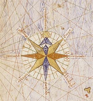
The Catalan Atlas is a world map drawn on vellum leaves in Majorca around 1375, attributed to the Jewish cartographer Abraham Cresques. Combining the precise coastlines of nautical charts with information from travellers, it shows the Mediterranean, Africa and Asia, including Mansa Musa of Mali holding a gold nugget. It entered the French royal library soon after and is now in the Bibliothèque nationale de France.
Mentioned in 2 profiles
Mentioned in 1 state history
See also



Cite this entry
- APA
- The Epoch Institute. (2026). Catalan Atlas. In The Epoch Institute Encyclopedia. https://the-epoch-institute.org/encyclopedia/catalan-atlas
- MLA
- “Catalan Atlas.” The Epoch Institute Encyclopedia, The Epoch Institute, 2026, https://the-epoch-institute.org/encyclopedia/catalan-atlas. Accessed .
- Chicago
- The Epoch Institute. “Catalan Atlas.” The Epoch Institute Encyclopedia. 2026. https://the-epoch-institute.org/encyclopedia/catalan-atlas.
- Harvard
- The Epoch Institute (2026) ‘Catalan Atlas’, The Epoch Institute Encyclopedia. Available at: https://the-epoch-institute.org/encyclopedia/catalan-atlas (Accessed: ).
Last reviewed October 2026Random entry ↻