Place · river
Apalachicola River
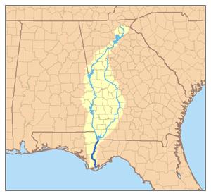
The Apalachicola River flows south through the Florida Panhandle into the Gulf of Mexico, formed where the Chattahoochee and Flint rivers meet at the Georgia border. In 1763 the British used it as the boundary between their new provinces of East and West Florida. Its valley was home to Creek and Seminole communities and the site of the Negro Fort, destroyed by US forces in 1816.
Mentioned in 1 state history
See also





Cite this entry
- APA
- The Epoch Institute. (2026). Apalachicola River. In The Epoch Institute Encyclopedia. https://the-epoch-institute.org/encyclopedia/apalachicola-river
- MLA
- “Apalachicola River.” The Epoch Institute Encyclopedia, The Epoch Institute, 2026, https://the-epoch-institute.org/encyclopedia/apalachicola-river. Accessed .
- Chicago
- The Epoch Institute. “Apalachicola River.” The Epoch Institute Encyclopedia. 2026. https://the-epoch-institute.org/encyclopedia/apalachicola-river.
- Harvard
- The Epoch Institute (2026) ‘Apalachicola River’, The Epoch Institute Encyclopedia. Available at: https://the-epoch-institute.org/encyclopedia/apalachicola-river (Accessed: ).
Last reviewed October 2026Random entry ↻